
It is fitting that this posting, as well as the two preceding, be about US hurricanes as this is the time for them to get generated off the coast of Africa and begin their journey to the US. The following charts show the US shore line, by county, along the Gulf of Mexico and the Atlantic Ocean and how many hurricanes have made landfall in those counties for the period of 1900 to 2010.
Beginning with chart 1 along the Gulf Coast:
 The scale on the right shows the range of strikes from 0 to 26+.
Chart 2 along the Eastern Gulf coast around to the Southern Atlantic Coast
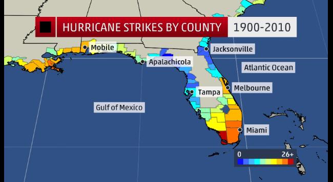
Chart 3 goes the South East Atlantic coast.

Chart 4 shows Mid-Atlantic coast

Chart 5 shows the Northeast coast

The charts are all courtesy of Weather.com
Some thoughts. Perhaps you could play the odds and say I can build along this coast line because hurricanes seldom strike here. One of my friends grew up on the Rhode Island/Connecticut border (see chart 5) and he tells of the massive hurricane that struck there in 1938. Chart 5 counties do not get pummeled like the Gulf coast, Florida on the Atlantic and the Gulf sides, and the northeastern part of North Carolina Chart 3). Anyway, I would not bet the farm based upon these charts.
When you are in the possible path of a hurricane, things can get pretty uncomfortable. No need tell you-all that, that live in counties frequently threatened. My first one was in Beaumont Tx. At the last moment it veered west toward the Winnie-Anahuac area and did not make to much of an impact on the Neches River area. In 2005 I worked with my son rehabbing his Tampa house that he wanted to sell. A hurricane was on its way and the exact landfall point was still being guessed at. I was told by the natives that Tampa almost never got hit by hurricanes. That hurricane was category 3 “Wilma”. Fortunately Wilma made land fall south of Tampa and none of the rehabbing work was ruined.
Lets hope that no big one come in this year.
cbdakota
